
HOME: www.hiltonpond.org |
|||
|
A Naturalist's View of |
|
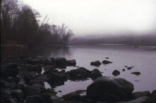
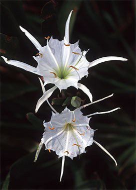
Bill Hilton Jr. Executive Director Hilton Pond Center for Piedmont Natural History The Catawba River originates as a mere trickle in North Carolina not far from Mount Mitchell. After it leaves its spring-fed headwaters in McDowell County, it accepts contributions from thousands of sources, including other springs and streams, run-off from farms and parking lots, and effluent from paper mills and sewage plants. Along the way to its confluence with the Wateree in South Carolina, the river's incredible power is harnessed by 11 major dams that form impoundments for recreation and power production. This majestic river, whose 200-mile length is split between North and South Carolina, flows through the heart of our two states, and it is a Piedmont treasure that has long been taken for granted or ignored. The Catawba is a river with many faces. At its beginning and approaching its end at Lake Wateree, it is largely undeveloped, while its mid-section is characterized by a dense concentration of homes and businesses and industries on Lakes Norman and Wylie. From the Rock Hill dam to the city of Lancaster, the Catawba River bottomland is pristine by today's standards; it is this stretch of the river in which Hilton Pond Center is most interested, and it is this section that is home to flora and fauna that we have observed and studied. And, not coincidentally, it is this section of the Catawba River that has the most to offer the citizens of South Carolina AND North Carolina if we act now to protect it. As part of our outreach education program, the Center's staff gives frequent public presentations. Although most speakers we've seen choose to end their slide shows with a picture of a brilliant sunset, we usually begin ours with a moonrise. Moonrises are much more subtle than sunsets, and many of the facts and concepts about nature and the Catawba River are equally subtle. The intricate balances of nature are often not as spectacular and as obvious as a flaming sunset; in fact, most interrelationships in nature only become apparent after years of study. It is for this reason that we encourage the powers-that-be to go slow in any development that might impact on the Catawba River or its tributaries, that every citizen pause a moment to consider just how valuable and important the Catawba is to us and its natural inhabitants. The Piedmont is a vast physiographic province that actually extends from northeast to southwest across a ten-state area, from southeastern New York, across Virginia and the Carolinas, and on into central Alabama. Historically, the Piedmont was a region of rich ecological diversity: dense expanses of forest; broad, open grasslands or savannas dotted with trees; and undisturbed bottomlands along an uncountable number of slow-moving rivers and streams. Despite popular opinion, the Piedmont was NOT an unbroken stretch of woodland, but was a mosaic of dissimilar and tightly interwoven habitats that resulted in an incredible diversity of plants and animals. Much of that natural diversity was centered around the waterways of the Piedmont, and it was this diversity and richness that attracted the first human settlers to the region. Significant Native American settlements along the Catawba certainly pre-dated the American Revolution, and there is speculation that humans lived along the Catawba thousands of years before the arrival of Europeans. Again, these native peoples came to the banks of the Catawba because it was home to deer and rabbits, because fishes proliferated in its waters, and because the alluvial soils laid down in its floodplain during periodic floods provided the best possible place to grow crops. Hard as it may be to believe, historical evidence indicates that bottomland areas along the Catawba and its tributaries may have contained up to six or eight FEET of topsoil--a far cry from the farmsteads of today where one or two inches of humus is considered a blessing. Native Americans probably farmed some stretches of the Catawba as we do today, clearing tracts of land to plant corn and other crops. Unlike modern farmers, however, native peoples cleared dozens or a few hundred acres, not thousands. In addition, they frequently allowed fields to lie fallow and regenerate naturally, and they certainly didn't use any broad-spectrum pesticides or fertilizers made from petrochemicals. In the years since the Native Americans were shoved aside, settlers of European origin have tended to dominate the Piedmont Region, taming it and molding it to their own needs and wishes. As a result, the Piedmont has become most fragmented major ecosystem in North America--a hodge-podge of cities and highways, farms and factories, and significant but ever-diminishing natural areas. In our judgment, the Piedmont is also the least-studied and most poorly understood ecosystem in the Carolinas. Everybody--including scientists--wants to go to the mountains and the beach, but nobody wants to stay close to home to investigate or enjoy the Piedmont! Thus, it's time for us to do our homework and examine at the Piedmont more carefully--especially those rare and limited riparian areas along the Catawba. And here's a word about buffers, perhaps the most controversial aspect of Catawba River management. A canoe trip along the lower portion of the waterway between the York/Lancaster county line and the city of Lancaster reveals a secret view that few South Carolinians have seen: a nearly unbroken stretch of riparian vegetation that is one of a handful of such resources in the Piedmont. Although the entire length of the Catawba was probably under crop farming or timbering at one time in the past 200 years, its bottomland hardwoods have made a remarkable comeback until today there is a reforested riparian corridor with great value to wildlife and people. It is amazing that below Rock Hill--except for a few pumping stations, an occasional power line crossing, a paper mill, and some regenerating logging tracts--both sides of the Catawba are solid walls of green for most of the river's length. Any canoe trip down the Catawba will reveal at least a few Southern Bald Eagles and a vast stand of Rocky Shoals Spider Lilies (below left)--both of which are endangered species providing testimony that the Catawba River is relatively untouched and appropriate for protection. Although science has long realized the basic importance of healthy riparian zones for resident wildlife and humans, ecologists are just beginning to understand the role that bottomland forests play in songbird migration, mammalian dispersal, and plant speciation. There is no question that extensive farming, logging, and development practices in the Piedmont have made it the most widely fragmented physiographic province in the Southeast. Many native species of plants and animals have been under siege by plow, chainsaw, and bulldozer for so long that some flora and fauna endemic to the Piedmont are unlikely to ever return. River bottoms, because of their relative inaccessibility to humans, often have been the last Piedmont areas to undergo wholesale development and, as such, are the only remaining habitats for many plants and animals. Therefore, any plan for development along the Catawba River must take into consideration the need to protect, preserve, and enhance significant portions of the bottomland corridor for now and for the future--and that means that riverside buffers must be more than the paltry 50 feet that is proposed by far too many interest groups. Even though we propose attention to subtle details in the environment, the typically proposed 50-foot buffer is far too subtle a way to protect habitat needed by plants and animals dependent upon the river. In the abstract, 50 feet may sound like a generous distance, but in reality it is the length of a mobile home, a tractor-trailer rig, or the span of a single mature oak. This, of course, is hardly sufficient space for the oak tree itself, much less the assortment of shrubs, grasses, and wildflowers needed to nurture the growth and survival of birds, butterflies, and other riparian creatures. Perhaps you've never thought about just how SMALL a 50-foot buffer really is, and perhaps you've taken for granted waterways such as the Catawba River. At Hilton Pond Center, we hope to stimulate everyone to take a deep breath and another look at the Catawba, and to do all we can to protect it for now and forever. We only get one chance, and this is it. |
 It is nearly unheard of to have such a natural gemstone so close to metropolitan areas the size of Rock Hill or Charlotte, and steps must be taken to protect the river corridor, its habitats, and its plants and animals.